
This post comes to us courtesy of our friend Oregon Matt. It is about contrails. There is math involved, some intimidating formulas presented, but the kind of formulas where all of us who took high school math could solve by inserting values. It’s not terribly difficult, but I don’t expect anyone to go running to the link by Clifford E. Carnicom just to see the formulas.
A little background about me. I have long operated on the assumption that contrails depend on the amount of moisture in the sky. If there’s a lot, then we see long tails behind jets flying over, and if the air is dry the contrails dissipate right away. Also, I assume that in addition to water vapor, the stuff coming out of the end of jet planes also contains nitrogen dioxide, sulfur dioxide, carbon dioxide and other invisible stuff. But according to Carnicom, what we see is virtually 100% water vapor.
When water comes out of a jet aircraft it is invisible. However the temperature at the elevation that jet aircraft fly is often in the area of -50°C below zero. So when the water vapor hits the air, crystals form. After that, the ice crystals are heated to the melting point by solar radiation. After that, crystals again form water vapor, and are invisible. Carnicom uses the following formula to calculate how much time it should take for a contrail to disappear.
t(sec) = ((d(u) * (9.17E-13) * (4.21dT + 335) J cm^3 gm kg m^3 s
m^2) / (Watts * 1E-12 J m^2 m^3 cm^3 gm kg)
I could list what the variables mean, or you can do what I did, just read the paper which is short and understandable to the non-mathematician. The key variable is “t”, or time that it takes for an ice crystal to form, liquefy, and vaporize. It depends on the size of the crystal, which can be anywhere from one micron to one hundred. Obviously, most ice crystals in contrails will fall somewhere in the middle of that. Also note, the ice crystals that form clouds are far, far smaller than those that form contrails, perhaps 1/100th the size. So the notion that contrails become clouds is wrong. Here are the results of the the math as worked out by Carnicorn:
1-50 600 1
10 -50 600 8
30 -50 600 25
50 -50 600 42
100 -50 600 831 -40 400 1
10 -40 400 12
30 -40 400 35
50 -40 400 58
100 -40 400 1151 -30 700 1
10 -30 700 6
30 -30 700 18
50 -30 700 33
100 -30 700 60
It can be read as follows (see last item): a 100 micron diameter ice crystal subjected to temperatures of -30°C and solar radiation of 700 W per square meter will dissolve and evaporate in 60 seconds.
According to Carnicom, there are no exceptions. When we see contrails in the air something is going on. I remember some time ago Miles Mathis addressed this issue, concluding that contrails that hang around for unduly long periods of time are really just a form of getting rid of industrial waste. That could well be. Others might theorize that we are being drugged, perhaps dumbed down, which would explain why so many millions of people flocked to be vaccinated.
Below I’m going to show a couple of pictures furnished by Oregon Matt, so you can see the kind of problems people in other parts of the world and country are having. Here in Colorado we rarely see more than a few contrails at any given time., but we do see them last for long periods of time.

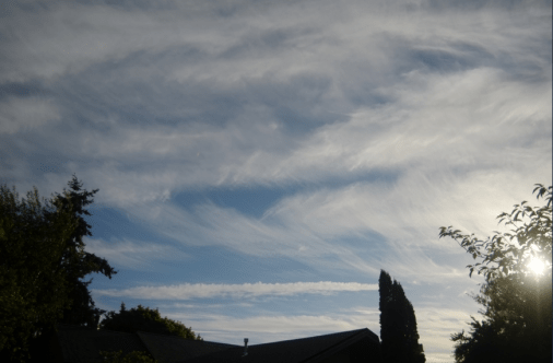
As you can see, contrails are much bigger issue than I ever thought they were.
Some of our readers here are well versed in engineering and the other sciences, so the math about contrails probably will not trouble them as much as it did me.

Here is northern England, not far from Leeds, we see these sort of “contrails” quite regularly. There are 2 types
1 those that disappear in 60 seconds or so as per your math. I call them contrails
2 those those that take literally hours to dissipate. This type tends to start as clearly visible puffs of vapour making the trail look like a fancy piece of ribbon. They then gradually smear across the sky like your photos. They can obliterate a blue sky if there are enough of them, which there sometimes are. I call them chemtrails
They try and conflate both types and to normalize them. But simple observation disproves that, they are NOT the same. Most definitely not. The long lasting ones are artificial, I’ve no doubt about that. No idea what they are. I’ve never seen anything definitive
Some folk have tied them to graphene a la Stephers previous work
LikeLiked by 1 person
Yep. I should have mentioned that when they linger in the air longer than the formula allows they should be called chemtrails. Thanks for filling that in.
LikeLike
Carnicom himself eschewed use of the term chemtrails, due to abuse from both the alternative and mainstream media, i.e. wild claims (no evidence) juxtaposed with scathing insults from the mainstream “debunkers”. He exclusively uses the term “aerosols” in his research on the subject….I’m not suggesting following suit, but just to say that his concern was to call it what it is, and back that up with science, and to avoid being lumped into the “chemtrail conspiracy crowd”.
To get more detail and coherence on the broader scope of the aerosol dispersion, I highly recommend this video made by Carnicom. https://www.youtube.com/watch?v=67ZKmVWB3tY&t=4724s As you watch, take note that many military, industrial, government, and pharmaceutical companies (to name some of the categories) seemed to have an interest in what Carnicom was disclosing on his new little website.
Many aerosol pics can be found online, of course, and some of the early papers that can be found in the index linked to by Steve below, have more examples, especially years 1999 and 2000.
A few of my photos are posted online (mostly plants and plant parts), but this link is to a gallery of my photos looking up at the sky. https://www.juzaphoto.com/me.php?pg=252374&l=en
LikeLike
Aerosol trails is a better description Matt. The billowing edges of the trail often look like they’ve been squirted out at 90 degrees from the direction of travel. They make whirling frills round the edge of the trail. I never see that with contrails
LikeLike
What are they hiding? Full disclosure would clear the air. NOT happening. Further reading on the subject here: https://www.transitieweb.nl/mirror-carnicom-institute/research-library-listing/index.html
LikeLiked by 1 person
The higher you go, up to the inversion layer, the lower the temperature, so the longer it takes to re-establish equilibrium. Ambient temperatures at mere cruising altitudes are already at -50 to -60 deg C, so should take longer to melt away, with decreased solar radiation they stay visible even longer, so near twilight they could be visible for much longer than the 115 seconds or almost 2 minutes you shared in the table.
Military aircraft can fly up to 50-60 km altitude even.
Thank you so much for sharing this Mark. Together with my own botulin toxin example I made it shows that “chemtrails” are fantasy and nothing more than military fearpr0n.
LikeLike
You didn’t read the Carnico paper, I take it. His take is a little more rigorous and detailed.
LikeLike
No I don’t read links or anything, that is not personal, yet my choice to stay unmarked.
But what is clear from what you shared is that the particle sizes, ambient temperature (largely a function of altitude) and solar radiation levels all affect the time trails stay visible.
So the higher the plane flies,
the colder it gets,
and the bigger the exhaust particle,
and/or the lower the solar radiation levels
the longer the ice-covered particles stay visible
Then the longer they are in the air, the longer they can refreeze again which can explain “hours” of visibility as Peter mentioned.
The higher those particles are released, the more (exponentially, not linearly) you need of them to “poison” us from the air.
LikeLike
One thing that troubles me, is that ice is ice, and radiation is radiation, no matter the altitude. We all agree that it gets colder as we go higher, but also that ice when encountering solar radiation is not dependent on the atmospheric temperature. It is a simple energy exchange where the ice warms to melt and then evaporates. Nothing of what you say here had any bearing on this, which is why Carncom focuses only on visible matter, ice, and a measure the temperatures by which it returns to invisible vapor using his formula. I do not know that military craft or passenger airlines interfere with this process, which is why his temperature and diameter were stratified based on differences, but each leading to a short duration for the aerosol. your theory does not explain long durations, especially for what we all see, long tails on passenger jets.
LikeLike
I don’t have any theory.
Other than that the criss cross patterns in the skies are “satellite” data acquisition programs, not “chemtrails”.
Or you mean re-freezing? That is hardly a theory, just an idea to explain longer times than the formula you shared would explain.
I am no expert on this, but chemtrails to poison us from the air do not make sense (that is why spray and fire fighting planes fly as low as possible), “satellite” data acquisition do make sense, because they explain
1 – the criss cross patterns we observe
2 – the fact we see those trails with good weather
3 – the altitudes those planes must fly for them to stay visible for so long
LikeLike
(still no edit function)
the higher the planes fly, the more data they can acquire in one flight, which makes sense for “satellite” data acquisition (albeit at the cost of lower resolution than lower altitude flights), while it does not make sense for spray planes, they need to fly as low as possible for them to be effective.
LikeLike
I wonder why they make designs in the air with the trails? There is more than one airplane in the sky and it’s always around the same time and they make X, cross pattern, or diagonal line patterns. That let’s me know these flights are not just a normal random jet plane fly by.
LikeLike
Indeed, that is why my thesis for those planes is that they are what the mainstream calls “satellites”. Those cross patterns are needed for coverage of the area to obtain photographic or other “satellite” data.
They don’t even hide it. Consult Google Maps “Satellite” View and in the bottom right it says “Boeing”, “Airbus”, etc.
That is imo the reason they push that “chemtrail” nonsense, to hide the real purpose of those planes and especially the patterns in the sky.
They have to, because man-made “satellites” cannot exist.
LikeLike
“They don’t even hide it. Consult Google Maps “Satellite” View and in the bottom right it says “Boeing”, “Airbus”, etc.”
Yes, and I’d like to expand a bit on that.
You can also read Maxar Technologies, Landsat, etc., but they’re all obvious fronts selling the same NASA’s snake oil baloneys.
Maxar Technologies claims that their flagship cutting edge satellites (WORLDVIEW-3), orbiting at 617 km altitude, provide at the very best a maximum visual resolution of 0.31 meter (Landsat claims much lower resolution).
To begin with, I’ve a hard time believing satellites can have lens capable of 0.31 m. resolution at 617 km, but supposing, for the sake of argument, that’s possible, I should be entitled to assume that anything smaller than the resolution power would be by definition merged/blurred into the background, becoming de facto indistinguishable (read invisible). Otherwise what’s the point of talking of resolution power in the first place? But correct me if I’m wrong.
If you take a look at Maxar images on Google Earth you can verify, for instance, that high voltage line cables are often easily visible. According to my online searching, the biggest high voltage cables (400 KV lines) never exceeds 10-12 cm in diameter (but most lines aren’t that high voltage, and cables significantly smaller), and that’s still about 1/3 of the Maxar’s claimed satellites maximum resolution power.
For some random examples I give you shortcuts to save you time, but there are plenty you can find on your own.
Go to (in decimal degrees):
LAT 4.540482 N LON 74.230021 W (this might be close to you)
LAT 22.953509 S LON 44.453881 W (Angra Brazil)
(you should read Maxar Technologies on bottom of image in GE, that’s what I read)
My take is that those cannot be satellite images.
Not sure I’m correct here, but if I am, that could amount to what Petra would call revelation of the method.
LikeLike
Excellent, grazie mille for this post that is much more advanced than my approach before, and also for looking up those locations, my tablet is not powerful enough. On my computer I took screenshots from a river in Queensland, Australia, where boats are cut in half with 2 different resolutions, I shared those sceencaps at Fakeo Discord before.
According to the narrative “we” are being monitored 24/7 by “satellites”, but instead of real time updates, they are individual surveys updating square or rectangular areas, fitting with planes flying over and not with the 24/7 satellite acquisition.
Ayokera, feel free to join the Eye am Eye Radio Discord, we have quite some members and your approach is solid and an example for others.
LikeLike
Thanks for the appreciation and the inviation. My favourite approach on any topic, as a truth seeker, is to find out if there’s a really solid core issue worth of debating, then go for it at full steam, avoiding like the plague all the useless sideways distractions that keep people endlessly circling in a maze. That said, of course anything can be “debunked” in fantasyland, but deep inside we all know it doesn’t really affect the matter at issue. When you are told that Santa’s reindeers can fly because they have “special properties” and if when you ask how they know that they answer “well of course they have, otherwise they won’t be flying!”, you know they’re desperate and climbing on soapy mirrors barehanded, as we use to say in italian.
I barely know what a radio discord is, that’s how fond I am of online social hubs and the like. It’s obviously centered on talking, but I ain’t never been the talking type, all the less in a foreign language of which I’ve a very limited mastering. I better keep sticking to my much more comfortably writing zone.
LikeLike
They are doing this in every city on the planet every few days for how many years? That’s alot of stuff floating around.
LikeLike
I rarely see cross patterns here, usually parallel tracks, also very acute angles, but never crisscross. Sometimes half of the sky is covered in parallel tracks. That often seems to happen when we’ve got a brilliant clear blue sky. Clear blue skies are not exactly commonplace here either so it’s very annoying on days like that because it dilutes the sunlight eventually blocking a lot of it out altogether
LikeLike
“But according to Carnicom, what we see is virtually 100% water vapor.”
Wow, that’s great technology!
The only time my car had 100% water vapor (and no – not even then) was when I had a blown head gasket.
If automobiles had the same engine technology – then we would not have such a pollution problem.
Call them “chem”-trails or call them “con”-trails – chemicals or conspiracy there really is a reason
LikeLike
“What we see” is not the same as “what is there”. The visible part of contrails is water. The invisible part compares to your car, not flying at X-thousand feet, and supposing the rings are not shot, gassing out an invisible plume of “stuff”.
LikeLike
Thanks – but I don’t see water…
What I do see is a con of chemical proportions. Usually on a cloudless day and then… within a hour or two… complete cloud (uhh, lack of a better word) coverage.
LikeLiked by 2 people
Howdy Kenneth,
We’re talking around each other. I agree completely with the description in your last comment. Many are the days when I have watched a clear sky become a hazy sky as the aerosols are dispersed in lines, then progress into haze, or sometimes fantastic shapes and geometric patterns. Clouds of “Chemical proportions”, indeed.
In my comment above I italicized “contrails”, because those plumes are water. I have photographed skies that include real contrails that have genuine, dissipating plumes, and chemtrails being delivered by other planes at the same time.
LikeLike
Meant to ask, where do you see the skies you describe?
LikeLike
Often times over my work, home, or just around the town. I don’t do much travelling, and I generally stay close to home. Nope, I don’t live in the city or countryside – but it is rural though.
LikeLike
What country, state, city region?
LikeLike
Oops – shoulda know you wanted a “location”, south of Savannah North of Brunswick (Georgia) that’s in the US of A, for everyone that doesn’t know. LoL
LikeLike
KENNETH, contrail is short for condensation trail not conspiracy. Chemicals or condensation there really is a difference.
LikeLike
Oh-kay
It’s funny (in a sad way); nobody listens to me unless I say something important.
It’s all just a word game after all.
LikeLiked by 1 person
Much like the possum and opossum.
It’s the same animal, just one word is used in the scientic community while the other word is not.
Condensation trail as an acceptable truth does not mean conspiracy cannot also be true.
*** to each their own
LikeLiked by 1 person
Condensation has nothing to do with conspiracy, nor is it another word for conspiracy.
Condensation = the conversion of a vapor or gas to a liquid
The discussion here is: is it a chemtrail, a visible trail left in the sky by an aircraft consisting chemical or biological agents, rather then the condensed water of a vapor trail, or just condensation (contrail)?
It’s not a potato potato (possum or opossum) thing.
LikeLike
https://www.geoengineeringwatch.org/geoengineering-definition-of-terms/
LikeLiked by 1 person
The best work I’ve found on the topic is by: “Rosalind Peterson was a Keynote Speaker at the 60th Annual DPI/NGO Conference on Climate Change (New York on September 5-7, 2007.) She spoke about agriculture and the negative impacts of experimental weather modification and other atmospheric programs on tree and plant health, increasing UV Radiation, aviation impacts on climate, and other …”. Also Jim Lee climateviewer.com and of course the name we all know Dane Wiggington at Geoengineeringwatch.com
Happy researching! 🙂
LikeLiked by 1 person
I have photos of this going back 10 years. And some last month while fishing. I surf the ‘net a lot and in the classifieds of FB autos & trucks you will see them. In ads both print & film going back DECADES. Sure you want to go there? Plenty of images of the planes used & the inside as well. At times one thick line will take an hour or so & it turn into a huge plume. Grids are very common. The X’s are mocking the bugs (people). Think of them like flying cans of RAID!
LikeLike
https://www.bitchute.com/video/IemDEoZj8qlk/ This link work here?
LikeLike
Yes it does work, thanks Motorhead
That video shows exactly the same as I see here in northern England. Usually not at the same level of intensity here as shown in the vid, nothing like so many planes in a short space of time. But exactly the same sort of frilly ribbon trails with whirling edges. And the same on/off effects and fatter trails too. I sometimes see the plane turn on the trail as it arrives over the densely populated areas south of here. Initially no trail whatsoever, then full on whirling ribbon trails that seem a lot fatter than normal contrails and which gets even fatter quite quickly
The planes don’t appear to be any higher than normal contrail type jets either, although I’ve no way of verifying that. If the plane was a lot higher then, it should surely seem a lot smaller too? I never see that
LikeLiked by 1 person
http://www.stopsprayingcalifornia.com/Chemtrail_Planes.php This link go through?
LikeLike
https://in5d.com/exposed-photos-from-inside-chemtrail-planes-like-youve-never-seen-before/ Last one.
LikeLike
Thank you, Motorhead. BA plus AL = BAAL
FYI: “Baal (also given as Ba’al) is a Canaanite-Phoenician god of fertility and weather, specifically rainstorms. The name was also used as a title, however, meaning “Lord” and was applied to a number of different deities throughout the ancient Near East. Baal is best known today from the Bible as the antagonist of the Israelite cult of Yahweh.” https://www.worldhistory.org/baal/
Agriculture in Mesopotamia (Iraq, Syria….) is where land division, deforestation, banking, debt, animal domestication/husbandry and all the other good stuff originated. The more things seem to change, the more they stay the same. Baaaaa!
LikeLike
BAAL & MOLECH are deities that children are sacrificed to by fire. Whoa unto thee.
LikeLike
Posting a few more pics of aerosol dispersion, aka as chemtrails. Notice the first three of the four illustrate how the original lines spread and change shape. In the vertically oriented pic, see near the bottom as air currents (presumably) are creating a novel pattern. The fourth pic illustrates how bizarre the patterns can become.


LikeLiked by 1 person
Pics three and four.


LikeLiked by 1 person
Nice parody, but who in the world would go to the trouble to make it?
LikeLike
It’s April 2022 and they are creating false ceilings all day everyday in southeast Michigan. Literally the sky will appear clear (to someone who doesn’t study the sky) then a little break happens and you see a real blue sky with planes crisscrossing constantly. I’ve captured so many things that would explain what they are covering – on top of the clear choice to dump poisonous chemicals and technology on humans for other purposes. It seems to be holding together a lot of “realities” at the moment. Also, altho beautiful- the constant rainbows – that are not natural – around the sun and moon are glaring warning signs in my opinion. But trying to show anyone the sky is futile, as I am sure everyone here knows. Happy to see new information in this thread I really appreciate it!
LikeLike